Contrary to viewing it as a static wetland, the Okavango Delta is a powerful hydraulic engine, constantly re-engineered by its wildlife and vegetation.
- Wildlife are not just inhabitants but « bio-engineers »; hippos dredge main arteries while termites construct islands.
- Vegetation, especially papyrus, acts as a counterforce, choking channels and forcing the water to carve new paths.
Recommendation: To understand the Okavango, shift your focus from a simple safari checklist to observing these dynamic forces of creation and obstruction at work.
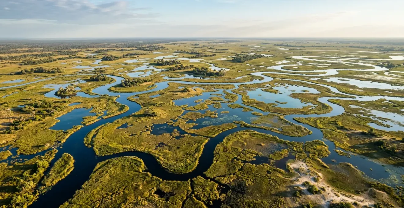
The Okavango Delta is often depicted as a serene, watery Eden—a fixed mosaic of islands and lagoons. For the geography enthusiast, however, this idyllic image belies a far more fascinating truth. The Delta is not a static landscape; it is a living, breathing circulatory system in a state of perpetual flux. To truly understand its hydrology, one must move beyond the ‘what’ and delve into the ‘how’ and ‘why’. Most guides will tell you that rains from Angola feed the delta, but they rarely explain the intricate mechanics of this six-month-long journey or the powerful forces that shape the water’s path upon its arrival.
The common understanding focuses on the results: beautiful waterways and abundant wildlife. But this perspective misses the main event. The true story of the Okavango is one of geomorphic tension—a relentless battle between the flow of water, the growth of vegetation, and the tireless work of its animal inhabitants. These are not passive players in a pre-made environment; they are the architects and engineers of the delta itself. This is a system where channels are not permanent fixtures but temporary victories in a war against vegetative blockage, and where islands rise from the work of insects.
This guide reframes the Okavango as a dynamic hydraulic engine. We will dissect the powerful, often unseen, forces that actively manage its plumbing. We will explore how hippos serve as biological dredgers, how papyrus growth can reroute entire rivers, and how the slow, powerful « fluvial pulse » from the Angolan highlands acts as the heartbeat for this entire ecosystem. By understanding these mechanisms, you can learn to read the landscape not as a picture, but as a story of constant, dynamic change.
This article deconstructs the key components of the delta’s living hydrology. The following sections explore each of the primary forces and actors that define the flow, blockage, and seasonal evolution of these world-famous waterways.
Summary: Deconstructing the Okavango’s Living Hydraulic System
- Why Are Hippos Called the « Architects of the Okavango Channels »?
- How Does Rapid Papyrus Growth Change the Course of Rivers?
- How Do Boat Captains Navigate Channels That Change Every Year?
- Why Do Termite Mounds Become Islands During the Flood?
- Tigerfish or Bream: What Can You Catch in the Deep Channels?
- How Does Rain in Angola Flood the Okavango 6 Months Later?
- Why Is the « Booze Cruise » Essential for the Okavango Experience?
- Motorboat Safari: How Is It Different from a Mokoro or Game Drive?
Why Are Hippos Called the « Architects of the Okavango Channels »?
Hippos are often viewed simply as large, water-dwelling mammals, but in the context of the Okavango’s hydrology, they are the primary ecosystem engineers. Their role is not passive; they are active and essential shapers of the landscape. Each night, these multi-ton animals move from the safety of deep water to terrestrial grazing areas, following the same paths with relentless consistency. Over time, their immense weight and constant movement compact the soil and clear vegetation, carving deep trenches into the delta’s substrate. These are not mere trails; they are the foundational arteries of the delta’s plumbing system.
These « hippo highways » function as nascent river channels. During the annual flood, water naturally seeks the path of least resistance, flowing into these pre-dredged, vegetation-free pathways. According to research on their impact, these pathways can be as much as 16 feet (5 meters) wide, creating significant conduits for water flow. As older channels nearby begin to fill with sand and sediment—a process known as avulsion—these hippo-maintained routes can capture the main flow and become major, permanent channels, effectively redesigning the delta’s map.
This function is so critical that their presence or absence can determine whether a region remains wet or dries out completely. As hydrologist Peter B. Moyle explains, their role is fundamental to the system’s structure:
Hippos are particularly important because their amphibious life style requires extensive daily movements between water and land. These movements create incised, vegetation-free pathways through which water can flow during flooding. These channels may become major river channels when the old channels fill with sand and avulse.
– Peter B. Moyle, ResearchGate – Fish, Floods, and Ecosystem Engineers
Without these biological dredgers, the delta’s waterways would quickly become impassable, choked by the aggressive growth of reeds and papyrus. The hippos, therefore, are not just living in the channels; they are actively creating and maintaining them, justifying their title as the primary architects of the Okavango.
How Does Rapid Papyrus Growth Change the Course of Rivers?
If hippos are the engineers that open the delta’s arteries, then papyrus (Cyperus papyrus) is the force that constantly threatens to clog them. This remarkable plant is perfectly adapted to the nutrient-rich, slow-moving waters of the Okavango. It grows at a prodigious rate, forming dense, seemingly impenetrable walls along the channels. The true challenge, however, lies beneath the surface. Papyrus spreads via a thick, interlocking network of buoyant rhizomes, which form a solid mat that can float on the water’s surface. Over time, these mats trap sediment and decaying organic matter, gradually becoming more solid and less permeable.
This process is known as vegetative blockage or hydro-choking. As a papyrus colony expands, it narrows the channel, slowing the water’s velocity. This reduced flow causes even more sediment to drop out of suspension, further building up the blockage. Eventually, the channel can become completely sealed. The immense pressure of the upstream floodwater builds until it is forced to break its banks and carve a new path through a weaker point in the landscape—a dramatic process of river avulsion. This is how the delta constantly redraws its own map; it’s a dynamic struggle between water flow and vegetative growth.
The intricate, dense root systems visible here demonstrate how papyrus forms a solid mat, effectively creating a biological dam that redirects water flow. A dramatic historical example highlights the critical balance of this system.
Case Study: The Consequence of Hippo Removal
In the south-western part of the Okavango Delta at the start of the 20th century, a period of extensive hippo hunting had unintended and drastic hydrological consequences. Without the constant movement of hippos to keep the channels open, the papyrus and other sedges grew unchecked. The waterways were completely choked by this rapid vegetation growth. As a result, the annual floodwaters could no longer penetrate the area. They were re-routed elsewhere in the delta, causing the entire south-west region to become progressively drier, transforming a lush wetland into an arid landscape.
How Do Boat Captains Navigate Channels That Change Every Year?
Navigating the Okavango Delta is a masterclass in reading a landscape that is alive and in constant motion. For boat captains and mokoro polers, a printed map is of little use from one year to the next. Their navigation relies on a deep, multi-generational understanding of hydrology, ecology, and animal behavior. It’s a form of science and art passed down through experience, not learned from a book. They are not just following known routes; they are interpreting the dynamic signals of the delta in real time.
The primary tool is an intimate knowledge of water itself. Captains read the speed and direction of the current, looking for subtle eddies or changes in surface texture that might indicate a submerged sandbank or a new blockage forming. The color and clarity of the water provide further clues; clearer, faster-moving water typically indicates a deep, established channel, while murky, stagnant water signals a shallow lagoon or a dead end. Vegetation is another key indicator. A line of shorter reeds might reveal a submerged hippo highway, a reliable path, whereas a solid wall of towering papyrus signals an impassable barrier.
Animal behavior provides another layer of navigational data. The presence of specific birds, like kingfishers, can indicate deep enough water for fish, suggesting a viable channel. A well-worn game trail leading to the water’s edge often marks a safe, shallow crossing point. This accumulated knowledge is a mental GIS system, constantly updated with new information shared among the community of guides. When a major channel blocks, or a new one opens, the word spreads quickly. It is this combination of empirical observation and shared local intelligence that allows them to « skillfully maneuver » through a fluid and unpredictable environment.
Action Plan: Reading the Delta’s Waterways
- Observe Flow Dynamics: Identify the main current by observing floating debris. Notice where the water speeds up (deep channel) versus where it slows and broadens (approaching a lagoon or blockage).
- Analyze Vegetation Patterns: Look for corridors of shorter, trampled reeds, which often indicate an active hippo path—a natural waterway. Contrast these with dense, tall stands of papyrus, which mark blockages.
- Check Water Clarity: Assess the water’s transparency. Clear, fast-moving water is a sign of a scoured, deep channel. Cloudy or dark, still water suggests shallow, sediment-rich areas.
- Scan for Animal Signatures: Note where game trails enter the water. Crocodiles basking on a bank often indicate a deeper pool nearby, while wading birds suggest shallower foraging grounds.
- Listen to the Landscape: Pay attention to the sounds. The loud grunting of hippos can pinpoint the location of a deep pool, which is often connected to the main channel system. A chorus of frogs indicates calmer, more vegetative waters.
Why Do Termite Mounds Become Islands During the Flood?
While hippos are the engineers of the delta’s waterways, termites are the master architects of its landmasses. The thousands of « islands » that dot the Okavango are not random geological formations. The vast majority are the result of meticulous, centuries-long bio-construction by termites. These insects build colossal mounds using a mixture of soil, saliva, and clay transported from deep underground. The mounds are incredibly dense and structurally sound, built to withstand the elements and, crucially, to rise above the seasonal floodwaters.
The process begins with a single colony building a mound that elevates their nest above the damp ground. As the colony thrives, the mound grows, sometimes reaching several meters in height and diameter. During the dry season, these mounds are simply features on the grassy plains. However, their true significance is revealed when the flood arrives. As the water spreads across the landscape, these towering termite mounds become the only patches of dry land for miles. In fact, it is estimated that termites have built around 70% of the islands in the Okavango Delta.
These mounds then become critical ecological sanctuaries. They provide a vital refuge for countless terrestrial species—from mongooses and monitor lizards to snakes and even large mammals—that would otherwise be displaced by the flood. This concentration of life turns each termite island into a miniature, self-contained ecosystem. Furthermore, the termites’ tunneling activity aerates the soil, and their nutrient-rich waste fertilizes it, allowing larger trees like the Real Fan Palm to take root. Over time, these trees help stabilize the island structure, creating the iconic palm-studded islands that define the Okavango, all thanks to the tireless work of these tiny engineers.
Tigerfish or Bream: What Can You Catch in the Deep Channels?
The delta’s complex plumbing, with its distinct habitats of fast-flowing channels and quiet lagoons, creates a corresponding diversity in its aquatic life. The Okavango is not a monolithic body of water; it is a system of interconnected but functionally different environments, each supporting specific species. For the angler and the naturalist, understanding this hydrological separation is key to knowing what life exists where. The delta is a remarkably rich freshwater fishery, and an analysis of its species reveals 85 recorded species of fish, each adapted to a particular niche within the system.
The two most iconic fish groups, tigerfish and bream, perfectly illustrate this principle of habitat specialization. The formidable tigerfish (Hydrocynus vittatus) is a voracious predator that thrives in the main, deep-water channels. It requires highly oxygenated, clear, and fast-flowing water where it can ambush its prey. These fish are rarely found in the still, vegetation-choked backwaters. Their presence is a direct indicator of a healthy, high-flow part of the delta’s circulatory system.
In stark contrast, various species of bream (tilapia) dominate the calmer, shallower lagoons and floodplains. These fish are adapted to slower-moving, nutrient-rich water where they feed on algae, insects, and plant matter. They find both food and protection from predators within the dense beds of water lilies and submerged vegetation that characterize these quieter parts of the delta. The type of fish you can catch is therefore a direct reflection of the specific hydraulic environment you are in.
The following table, based on expert observations, breaks down the distinct environmental preferences of these two key fish types, highlighting how the delta’s plumbing dictates its biodiversity.
| Fish Type | Preferred Habitat | Water Conditions | Fishing Method |
|---|---|---|---|
| Tigerfish | Fast-flowing main channels | Highly oxygenated, clear water | Trolling and spinning |
| Bream | Vegetation-rich lagoons | Slower-moving, nutrient-rich | Float fishing near vegetation |
How Does Rain in Angola Flood the Okavango 6 Months Later?
The lifeblood of the Okavango Delta originates over 1,000 kilometers away in the highlands of Angola. The annual rains that fall there from October to April are the sole source of the flood. Yet, a perplexing question for many visitors is why this water takes so long—up to six months—to reach the heart of the delta. The answer lies not in distance, but in one of the most fundamental principles of hydrology: gradient. The journey of the Okavango River is one of the slowest and flattest on Earth.
From its entry into Botswana to its terminus in the alluvial fan, the river’s descent is astonishingly gentle. Data shows the incredibly gentle slope shows only a 60 meters drop over 450 kilometers. This is equivalent to a gradient of approximately 1:7500. To put that in perspective, a standard wheelchair ramp has a gradient of 1:12. The water is flowing across a surface that is, for all practical purposes, almost perfectly flat. This lack of gravitational pull means the water moves incredibly slowly, creeping forward rather than rushing.
This slow-motion advance, known as the « fluvial pulse, » is further impeded by the friction from channel beds and dense vegetation. The river first fills the vast, swampy Panhandle region before it can spill out into the iconic fan-shaped delta. This entire process acts as a massive natural regulator, absorbing the huge influx of water and releasing it slowly and predictably. Every year, around 11km³ of water enters the swamps, but it takes several months for this pulse to travel from the Angolan highlands to its final destination, creating the reliable, life-giving flood that defines the Okavango ecosystem, arriving paradoxically during Botswana’s dry season.
Why Is the « Booze Cruise » Essential for the Okavango Experience?
The term « booze cruise » is a colloquial and somewhat misleading name for what is, hydrologically and biologically, one of the most significant events of the day in the delta: the sunset boat safari. While it is certainly a pleasant social ritual, its real value lies in witnessing the landscape at a moment of profound transition. As the sun sets, two critical environmental factors change: temperature and light levels. These are not merely aesthetic changes; they are powerful biological triggers that initiate a cascade of activity throughout the ecosystem.
As the air and water cool, and the golden-hour light fades, the delta shifts from its daytime to its nighttime operational mode. This transition is a key moment for observing wildlife behavior that is otherwise hidden. The dropping temperature and changing light levels are a signal for a host of behaviors. As one expert notes, this is the time when life in the channels changes dramatically.
The dropping temperature and changing light levels are a biological signal for a host of behaviors, from fish moving into the shallows to avoid nocturnal predators to crocodiles positioning themselves for a night of hunting.
– Safari Wildlife Behavioral Expert, Okavango Wildlife Activity Patterns Study
This is when the famously lethargic hippos become vocal and active, beginning their nightly commute to grazing grounds. It’s when the explosive chorus of frogs and insects erupts, replacing the calls of daytime birds. Nocturnal predators like crocodiles reposition themselves for ambush, and shy creatures begin to emerge. The sunset safari, therefore, is not just about enjoying a drink with a view; it is a front-row seat to the daily handover between two entirely different worlds, driven by the fundamental environmental cues of light and temperature.
Key takeaways
- The Delta’s plumbing is actively dredged by hippos, whose pathways form the basis for major water channels.
- Papyrus growth provides a powerful counterforce, choking waterways and causing river avulsion, which constantly reshapes the landscape.
- The entire system is powered by a slow, massive « fluvial pulse » from Angola, a six-month process dictated by an incredibly gentle gradient.
Motorboat Safari: How Is It Different from a Mokoro or Game Drive?
Understanding the Okavango as a dynamic plumbing system of channels, lagoons, and islands allows one to appreciate why different safari methods are not interchangeable. Each mode of transport—game drive vehicle, mokoro (dugout canoe), and motorboat—is a specialized tool designed to explore a specific component of this complex environment. Choosing a safari type is effectively choosing which part of the delta’s hydraulic and ecological system you want to experience. A game drive is a terrestrial experience, while mokoros and motorboats offer two fundamentally different aquatic perspectives.
The game drive vehicle is designed for the plains and woodlands that exist on the larger, more permanent islands. Its perspective is fixed on the terrestrial ecosystem: lions, elephants, and antelope that live on the ‘dry land’ component of the delta. In contrast, the mokoro offers an intimate, water-level micro-view. Propelled silently by a poler, it is perfectly suited for the shallow, narrow, vegetation-rich backwaters and lagoons. It allows for close, non-disruptive encounters with the small-scale life of the delta: frogs, water lilies, insects, and small birds. It is an experience of immersion and quiet detail.
The motorboat provides a completely different, systems-level perspective. It is built for the deep, fast-flowing main channels—the highways of the delta’s plumbing. A motorboat safari is not about quiet intimacy but about scale, power, and connectivity. It allows you to cover large distances, moving from the main arteries to large, open lagoons, demonstrating how the entire system is interconnected. This is the best way to access aquatic predators like crocodiles, large pods of hippos in their deep-water refuges, and vast colonies of water birds. It offers a macro-level demonstration of the delta’s living hydrology in action.
This table summarizes the distinct role each safari type plays in exploring the Okavango’s multifaceted environment.
| Safari Type | Perspective | Coverage | Wildlife Access | Experience |
|---|---|---|---|---|
| Game Drive | Terrestrial view | Plains and woodlands | Large mammals on land | Big picture of savanna ecosystem |
| Mokoro | Water-level micro view | Shallow channels | Frogs, water lilies, small birds | Intimate, silent, slow-paced |
| Motorboat | Systems-level view | Deep channels to lagoons | Aquatic predators, bird colonies | Delta connectivity demonstration |
To truly appreciate this hydraulic marvel, the next step is to witness these forces in action. Plan your expedition not just to see wildlife, but to observe the living mechanics of the delta firsthand.
Frequently asked questions about The Okavango Experience
What wildlife is most active during sunset boat trips?
Hippos become vocal and active, nocturnal creatures like genets and civets emerge, and birds perform their evening roosting rituals.
Why is the ‘golden hour’ important for photography?
The low-angle light creates strong silhouettes, highlights animal tracks on riverbanks, and provides warm tones that enhance wildlife photography.
What unique sounds can be heard during sunset cruises?
The transition includes the fading of daytime bird calls replaced by an explosive chorus of frogs, insects, and the signature grunts and bellows of hippos.